File:Fiji map.png
冇更高解像度嘅圖像。
Fiji_map.png (324 × 349 像素,檔案大細:11 KB ,MIME類型:image/png)

|
This map has been uploaded by Electionworld from en.wikipedia.org to enable the |
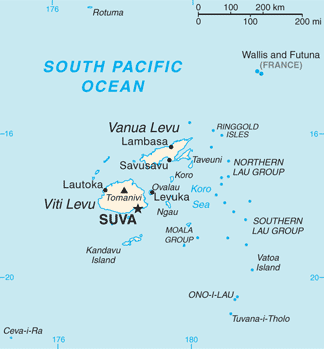
PNG map of Fiji from CIA World Factbook.
This image is in the public domain because it contains materials that originally came from the United States Central Intelligence Agency's World Factbook.
|
 |
Originally uploaded to English Wikipedia by en:User:Grendelkhan as Fj-map.png.

|
This map image could be recreated using vector graphics as an SVG file. This has several advantages; see Commons:Media for cleanup for more information. If an SVG form of this image is already available, please upload it. After uploading an SVG, replace this template with {{vector version available|new image name.svg}}.
|
檔案歷史
撳個日期/時間去睇響嗰個時間出現過嘅檔案。
| 日期/時間 | 縮圖 | 尺寸 | 用戶 | 註解 | |
|---|---|---|---|---|---|
| 現時 | 2013年5月1號 (三) 13:26 | | 324 × 349(11 KB) | Ras67 | cropped |
| 2012年9月16號 (日) 17:14 |  | 328 × 353(23 KB) | Thricecube | Updated version | |
| 2012年6月26號 (二) 17:33 |  | 326 × 351(4 KB) | Ras67 | cropped | |
| 2005年3月12號 (六) 03:18 |  | 330 × 355(4 KB) | Alexander Ilnitsky~commonswiki | Map of Fiji |
檔案用途
無嘢連來呢份檔案。
全域檔案使用情況
下面嘅維基都用緊呢個檔案:
- af.wikipedia.org嘅使用情況
- als.wikipedia.org嘅使用情況
- am.wikipedia.org嘅使用情況
- ang.wikipedia.org嘅使用情況
- ar.wikipedia.org嘅使用情況
- arz.wikipedia.org嘅使用情況
- ast.wikipedia.org嘅使用情況
- azb.wikipedia.org嘅使用情況
- az.wikipedia.org嘅使用情況
- ban.wikipedia.org嘅使用情況
- ba.wikipedia.org嘅使用情況
- bcl.wikipedia.org嘅使用情況
- be-tarask.wikipedia.org嘅使用情況
- bn.wikipedia.org嘅使用情況
- br.wikipedia.org嘅使用情況
- ca.wikipedia.org嘅使用情況
- ceb.wikipedia.org嘅使用情況
- cs.wikipedia.org嘅使用情況
- cy.wikipedia.org嘅使用情況
- de.wikipedia.org嘅使用情況
- de.wikivoyage.org嘅使用情況
- dsb.wikipedia.org嘅使用情況
- el.wikipedia.org嘅使用情況
- en.wikipedia.org嘅使用情況
睇呢個檔案嘅更多全域使用情況。