File:French Indochina subdivisions.svg

呢個「SVG」檔案嘅呢個「PNG」預覽嘅大細:393 × 599 像素。 第啲解像度:157 × 240 像素|315 × 480 像素|504 × 768 像素|671 × 1,024 像素|1,343 × 2,048 像素|667 × 1,017 像素。
原本檔案 (SVG檔案,表面大細: 667 × 1,017 像素,檔案大細:150 KB)

THIS MAP IS SO WRONG AND NO ONE EVEN BOTHERS TO FIX IT. Now it's spread all over the internet, and even poor college professors use it for their lectures and presentations.
Someone please FIX it. Check the boundaries between Tonkin & Annam as well as between Annam & Cochinchina. The damn Vung Tau is being weird too.
摘要
| 描述 |
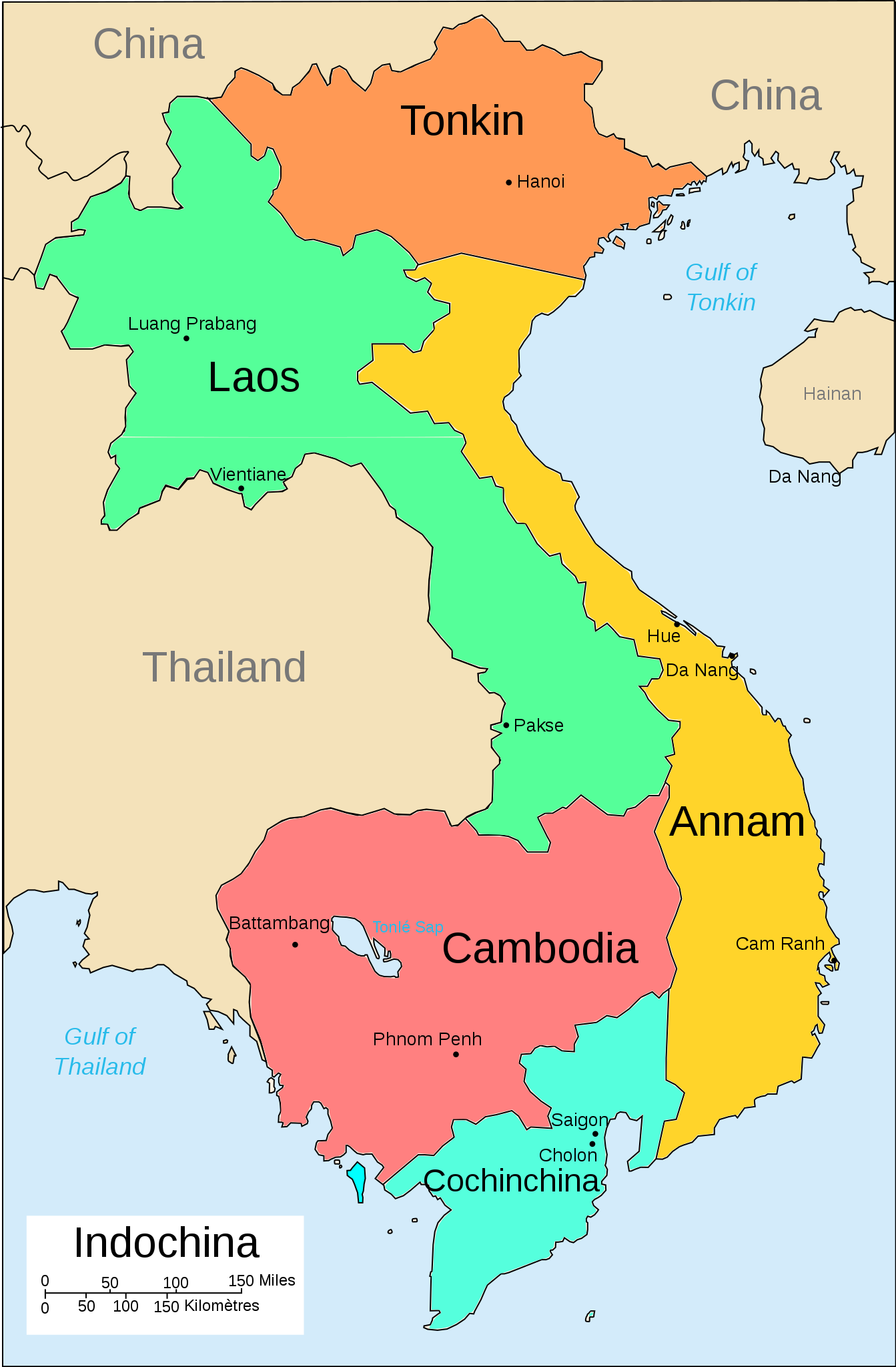
English: A map of the subdivision of the French Indochina federation |
| 日期 | |
| 來源 | 自己作品 |
| 作者 | Bearsmalaysia |
| Other versions |
Српски / srpski: File:French Indochina subdivisions sr.svg |
協議
我,呢份作品嘅作者,決定用以下許可發佈呢件作品:
呢個檔案用共享創意 姓名標示-非商業性-相同方式分享3.0 未本地化版本條款授權。
- 你可以:
- 去分享 – 複製、發佈同傳播呢個作品
- 再改 – 創作演繹作品
- 要遵照下面嘅條件:
- 署名 – 你一定要畀合適嘅表彰、畀返指向呢個授權條款嘅連結,同埋寫明有無改過嚟。你可以用任何合理方式去做,但唔可以用任何方式暗示授權人認可咗你或者你嘅使用方式。
- 相同方式分享 – 如果你用任何方式改過呢個作品,你必須要用返原本或者相似嘅條款發佈。
檔案歷史
撳個日期/時間去睇響嗰個時間出現過嘅檔案。
| 日期/時間 | 縮圖 | 尺寸 | 用戶 | 註解 | |
|---|---|---|---|---|---|
| 現時 | 2013年5月3號 (五) 16:36 | | 667 × 1,017(150 KB) | Bearsmalaysia | Fixed Tonkin-Annam border for second time |
| 2013年5月3號 (五) 16:23 |  | 667 × 1,017(133 KB) | Bearsmalaysia | Adjusted Tonkin-Annam border, coloured Phu Quoc island (part of Cochinchina) and cleaned up some errors | |
| 2013年3月31號 (日) 19:57 |  | 667 × 1,017(135 KB) | Bearsmalaysia | oops...the word 'Phnom Penh' duplicated | |
| 2013年3月31號 (日) 19:55 |  | 667 × 1,017(134 KB) | Bearsmalaysia | User created page with UploadWizard |
檔案用途
全域檔案使用情況
下面嘅維基都用緊呢個檔案:
- af.wikipedia.org嘅使用情況
- ast.wikipedia.org嘅使用情況
- az.wikipedia.org嘅使用情況
- en.wikipedia.org嘅使用情況
- eo.wikipedia.org嘅使用情況
- gl.wikipedia.org嘅使用情況
- he.wikipedia.org嘅使用情況
- hi.wikipedia.org嘅使用情況
- id.wikipedia.org嘅使用情況
- io.wikipedia.org嘅使用情況
- it.wikipedia.org嘅使用情況
- lt.wikipedia.org嘅使用情況
- lv.wikipedia.org嘅使用情況
- nl.wikipedia.org嘅使用情況
- no.wikipedia.org嘅使用情況
- pl.wikipedia.org嘅使用情況
- sh.wikipedia.org嘅使用情況
- uk.wikipedia.org嘅使用情況
- vi.wikipedia.org嘅使用情況
- www.wikidata.org嘅使用情況
- zh.wikipedia.org嘅使用情況