File:Iron Curtain map.svg

呢個「SVG」檔案嘅呢個「PNG」預覽嘅大細:560 × 599 像素。 第啲解像度:224 × 240 像素|449 × 480 像素|718 × 768 像素|957 × 1,024 像素|1,914 × 2,048 像素|645 × 690 像素。
原本檔案 (SVG檔案,表面大細: 645 × 690 像素,檔案大細:322 KB)
摘要
| 描述 |
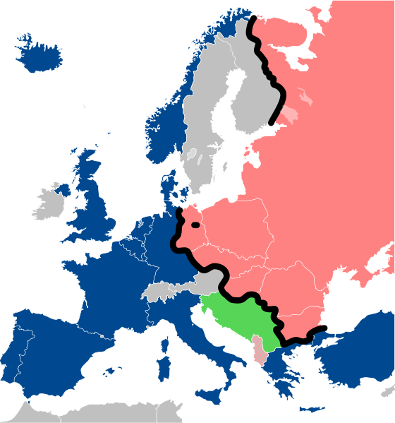
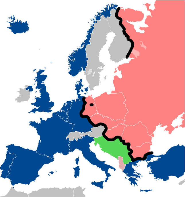
Lëtzebuergesch: Kaart vum Westen an dem Ostblock an Europa während dem Kale Krich.
"Eise Rido"
Neutral Länner
|
||
| 日期 | |||
| 來源 |
Travail personnel (own work). Sources:
|
||
| 作者 | Sémhur | ||
| Other versions |
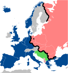
File:Iron Curtain map alternative.svg (Same, but with Yugoslavia on the Eastern side of the Iron Curtain.) | ||
| 姓名標示 (required by the license) | © Sémhur / Wikimedia Commons / | ||
| SVG | W3C-validity not checked.
|
||
| Graphic Lab |

| Camera location | | View this and other nearby images on: OpenStreetMap |
|---|
協議
I, the copyright holder of this work, hereby publish it under the following licenses:
| Copyleft: This work of art is free; you can redistribute it and/or modify it according to terms of the Free Art License. You will find a specimen of this license on the Copyleft Attitude site as well as on other sites. |
This file is licensed under the Creative Commons Attribution-Share Alike 4.0 International, 3.0 Unported, 2.5 Generic, 2.0 Generic and 1.0 Generic license.
- 你可以:
- 去分享 – 複製、發佈同傳播呢個作品
- 再改 – 創作演繹作品
- 要遵照下面嘅條件:
- 署名 – 你一定要畀合適嘅表彰、畀返指向呢個授權條款嘅連結,同埋寫明有無改過嚟。你可以用任何合理方式去做,但唔可以用任何方式暗示授權人認可咗你或者你嘅使用方式。
- 相同方式分享 – 如果你用任何方式改過呢個作品,你必須要用返原本或者相似嘅條款發佈。
你可以揀你想用嘅牌照。
檔案歷史
撳個日期/時間去睇響嗰個時間出現過嘅檔案。
| 日期/時間 | 縮圖 | 尺寸 | 用戶 | 註解 | |
|---|---|---|---|---|---|
| 現時 | 2022年12月15號 (四) 13:26 | | 645 × 690(322 KB) | PhotographyEdits | Extend the Iron Curtain eastwards of Yugoslavia. Even though Yugoslavia was not really considered part of the West, the currenet map gives the false impression that there was a huge gap in the Iron Curtain, which wasn't the case. |
| 2022年7月23號 (六) 00:56 |  | 645 × 690(321 KB) | Kwamikagami | NATO blue, #004990 | |
| 2019年3月30號 (六) 20:30 |  | 645 × 690(321 KB) | Sémhur | Reverted to version as of 07:07, 27 May 2014 (UTC). Albania leaves the Waras Pack in middle of cold war; this is why it's shown wtih stripes. | |
| 2019年3月24號 (日) 09:18 |  | 512 × 548(123 KB) | Hakuli | Albania leaves the Waras Pack in middle of cold war | |
| 2014年5月27號 (二) 07:07 |  | 645 × 690(321 KB) | Sémhur | Valid SVG | |
| 2010年11月16號 (二) 13:51 |  | 645 × 690(321 KB) | Sémhur | Added Iron Curtain between Bulgaria and Greece & Turkey. | |
| 2008年9月27號 (六) 16:57 |  | 645 × 690(321 KB) | Sémhur | Correcting mistake : Austria wasn't in NATO. | |
| 2008年5月31號 (六) 10:51 |  | 645 × 690(330 KB) | Sémhur | {{Information |Description={{en|1=Map of the Iron Curtain in Europe.}} {{fr|1=Carte du rideau de fer en Europe.}} {{es|1=Mapa del Telón de Acero en Europa.}} |Source=Travail personnel (ow |
檔案用途
以下嘅1版用到呢個檔:
全域檔案使用情況
下面嘅維基都用緊呢個檔案:
- af.wikipedia.org嘅使用情況
- als.wikipedia.org嘅使用情況
- ar.wikipedia.org嘅使用情況
- ast.wikipedia.org嘅使用情況
- azb.wikipedia.org嘅使用情況
- az.wikipedia.org嘅使用情況
- ba.wikipedia.org嘅使用情況
- be-tarask.wikipedia.org嘅使用情況
- be.wikipedia.org嘅使用情況
- bg.wikipedia.org嘅使用情況
- br.wikipedia.org嘅使用情況
- bs.wikipedia.org嘅使用情況
- ca.wikipedia.org嘅使用情況
- cs.wikipedia.org嘅使用情況
- cy.wikipedia.org嘅使用情況
- da.wikipedia.org嘅使用情況
- de.wikipedia.org嘅使用情況
- el.wikipedia.org嘅使用情況
- el.wiktionary.org嘅使用情況
- en.wikipedia.org嘅使用情況
- en.wikibooks.org嘅使用情況
- en.wikiquote.org嘅使用情況
- en.wiktionary.org嘅使用情況
睇呢個檔案嘅更多全域使用情況。