File:Ketsana 2009 track.png
原本檔案 (2,700 × 1,669 像素,檔案大細:3.04 MB ,MIME類型:image/png)
摘要
| 描述 |
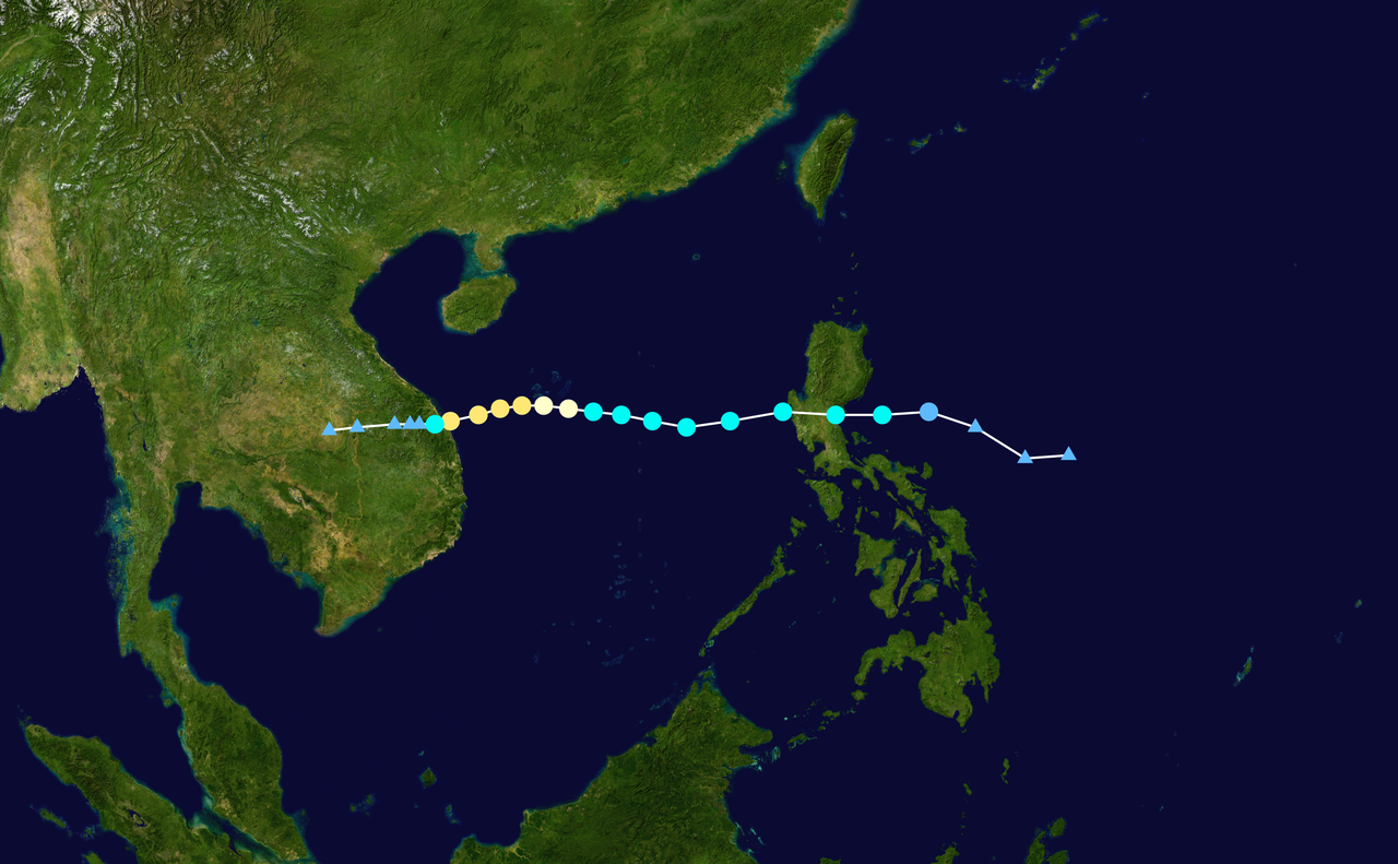
English: Track map of Typhoon Ketsana of the 2009 Pacific typhoon season. The points show the location of the storm at 6-hour intervals. The colour represents the storm's maximum sustained wind speeds as classified in the (see below), and the shape of the data points represent the nature of the storm, according to the legend below. Tropical depression (≤38 mph, ≤62 km/h)
Tropical storm (39–73 mph, 63–118 km/h)
Category 1 (74–95 mph, 119–153 km/h)
Category 2 (96–110 mph, 154–177 km/h)
Category 3 (111–129 mph, 178–208 km/h)
Category 4 (130–156 mph, 209–251 km/h)
Category 5 (≥157 mph, ≥252 km/h)
Unknown
Storm type |
||
| 日期 | 2009-09-25–2009-09-30 | ||
| 來源 | Created by Cyclonebiskit using Wikipedia:WikiProject Tropical cyclones/Tracks. The background image is from NASA. Tracking data is from the Joint Typhoon Warning Center[1]. | ||
| 作者 | Cyclonebiskit | ||
| Source code | Track map data table, if present below, is in HURDAT2 or ATCF format. See format details in [2] and [3], respectively.
|
協議
| This work has been released into the public domain by its author, Cyclonebiskit. This applies worldwide. In some countries this may not be legally possible; if so: Cyclonebiskit grants anyone the right to use this work for any purpose, without any conditions, unless such conditions are required by law. |
檔案歷史
撳個日期/時間去睇響嗰個時間出現過嘅檔案。
| 日期/時間 | 縮圖 | 尺寸 | 用戶 | 註解 | |
|---|---|---|---|---|---|
| 現時 | 2020年7月3號 (五) 20:28 |  | 2,700 × 1,669(3.04 MB) | Supportstorm | JTWC/JMA data |
| 2019年12月21號 (六) 01:30 |  | 2,700 × 1,669(3.29 MB) | FleurDeOdile | IBTrACS data | |
| 2010年7月31號 (六) 01:34 |  | 1,024 × 633(532 KB) | Cyclonebiskit | update with best track | |
| 2009年10月1號 (四) 01:59 |  | 1,024 × 633(516 KB) | Cyclonebiskit | update | |
| 2009年9月28號 (一) 19:48 |  | 1,024 × 633(451 KB) | Cyclonebiskit | update | |
| 2009年9月28號 (一) 12:40 |  | 1,024 × 633(431 KB) | Cyclonebiskit | update | |
| 2009年9月28號 (一) 07:54 |  | 1,024 × 633(392 KB) | Cyclonebiskit | update | |
| 2009年9月27號 (日) 20:24 |  | 1,024 × 633(372 KB) | Cyclonebiskit | {{Information |Description={{en|Track map of Tropical Storm Ketsana of the 2009 Pacific typhoon season. The points show the location of the storm at 6-hour intervals. The colour represe |
檔案用途
以下嘅3版用到呢個檔:
全域檔案使用情況
下面嘅維基都用緊呢個檔案:
- cs.wikipedia.org嘅使用情況
- de.wikipedia.org嘅使用情況
- de.wikinews.org嘅使用情況
- en.wikipedia.org嘅使用情況
- en.wikinews.org嘅使用情況
- fr.wikipedia.org嘅使用情況
- it.wikipedia.org嘅使用情況
- ja.wikipedia.org嘅使用情況
- ko.wikipedia.org嘅使用情況
- pl.wikipedia.org嘅使用情況
- pt.wikipedia.org嘅使用情況
- tl.wikipedia.org嘅使用情況
- vi.wikipedia.org嘅使用情況
- zh.wikipedia.org嘅使用情況