File:Map PMNM 2016.jpg

預覽大細:800 × 445 像素。 第啲解像度:320 × 178 像素|640 × 356 像素|1,200 × 667 像素。
原本檔案 (1,200 × 667 像素,檔案大細:249 KB ,MIME類型:image/jpeg)

|
This map image could be recreated using vector graphics as an SVG file. This has several advantages; see Commons:Media for cleanup for more information. If an SVG form of this image is already available, please upload it. After uploading an SVG, replace this template with {{vector version available|new image name.svg}}.
|


摘要
| 描述 |
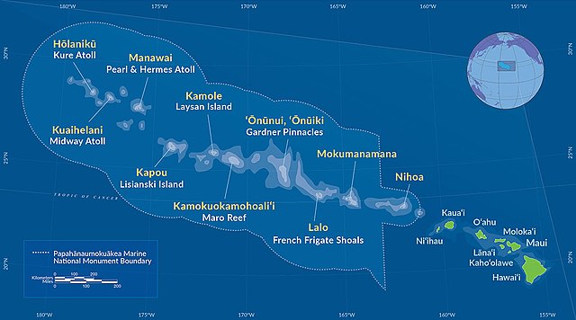
Deutsch: Karte des Papahānaumokuākea Marine National Monument (2016)
English: Map of Papahānaumokuākea Marine National Monument (2016) |
| 日期 | |
| 來源 | http://www.papahanaumokuakea.gov/ |
| 作者 | NOAA |
協議
This image is in the public domain because it contains materials that originally came from the U.S. National Oceanic and Atmospheric Administration, taken or made as part of an employee's official duties.
|
檔案歷史
撳個日期/時間去睇響嗰個時間出現過嘅檔案。
| 日期/時間 | 縮圖 | 尺寸 | 用戶 | 註解 | |
|---|---|---|---|---|---|
| 現時 | 2016年8月28號 (日) 09:29 | | 1,200 × 667(249 KB) | NordNordWest | == {{int:filedesc}} == {{Information |Description={{de|Karte des Papahānaumokuākea Marine National Monument (2016)}} {{en|Map of [[:en:Papahānaumokuākea Marine National Monument|Papahānaumokuāk... |
檔案用途
以下嘅1版用到呢個檔:
全域檔案使用情況
下面嘅維基都用緊呢個檔案:
- de.wikipedia.org嘅使用情況
- en.wikipedia.org嘅使用情況
- es.wikipedia.org嘅使用情況
- fr.wikipedia.org嘅使用情況
- gl.wikipedia.org嘅使用情況
- hr.wikipedia.org嘅使用情況
- id.wikipedia.org嘅使用情況
- it.wikipedia.org嘅使用情況
- ja.wikipedia.org嘅使用情況
- la.wikipedia.org嘅使用情況
- lt.wikipedia.org嘅使用情況
- mr.wikipedia.org嘅使用情況
- pl.wikipedia.org嘅使用情況
- sr.wikipedia.org嘅使用情況
- tr.wikipedia.org嘅使用情況
- uk.wikipedia.org嘅使用情況
- vi.wikipedia.org嘅使用情況
- www.wikidata.org嘅使用情況
- zh.wikipedia.org嘅使用情況