File:O'Hare International Airport (USGS).png
預覽大細:488 × 599 像素。 第啲解像度:195 × 240 像素|391 × 480 像素|743 × 912 像素。
原本檔案 (743 × 912 像素,檔案大細:1.56 MB ,MIME類型:image/png)
.png?uselang=yue)
| 描述 |
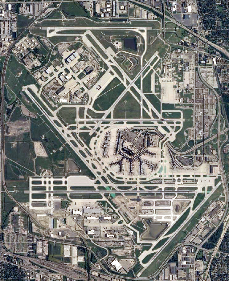
English: Satellite image of Chicago O'Hare International Airport |
|||
| 日期 | ||||
| 來源 | USGS National Map Viewer | |||
| 作者 |
|
檔案歷史
撳個日期/時間去睇響嗰個時間出現過嘅檔案。
| 日期/時間 | 縮圖 | 尺寸 | 用戶 | 註解 | |
|---|---|---|---|---|---|
| 現時 | 2011年11月29號 (二) 19:51 | | 743 × 912(1.56 MB) | Nathan Johnson | color levels |
| 2011年10月13號 (四) 10:41 |  | 743 × 912(1.46 MB) | Nickvet419 | ({{Information| |Description= |Source=USGS National Map Viewer |Date=October 13, 2011|Author={{PD-USGov-USGS}} |Permission= |other_versions= }} ) | |
| 2007年6月17號 (日) 00:08 |  | 1,132 × 1,132(2.14 MB) | Brianski | File sized slightly reduced via optipng -o7 | |
| 2006年5月14號 (日) 09:24 |  | 1,132 × 1,132(2.18 MB) | Wangi | zoom in a bit | |
| 2006年3月27號 (一) 18:44 |  | 1,680 × 1,050(3.08 MB) | Keeleysam | {{Information| |Description= |Source=NASA World Wind Screenshot |Date= |Author={{PD-USGov-USGS}} |Permission= |other_versions= }} |
檔案用途
以下嘅1版用到呢個檔:
全域檔案使用情況
下面嘅維基都用緊呢個檔案:
- af.wikipedia.org嘅使用情況
- ar.wikipedia.org嘅使用情況
- arz.wikipedia.org嘅使用情況
- ast.wikipedia.org嘅使用情況
- bg.wikipedia.org嘅使用情況
- ckb.wikipedia.org嘅使用情況
- cs.wikipedia.org嘅使用情況
- da.wikipedia.org嘅使用情況
- de.wikipedia.org嘅使用情況
- de.wikivoyage.org嘅使用情況
- en.wikivoyage.org嘅使用情況
- eu.wikipedia.org嘅使用情況
- fa.wikipedia.org嘅使用情況
- fi.wikipedia.org嘅使用情況
- fr.wikipedia.org嘅使用情況
- fr.wikivoyage.org嘅使用情況
- fy.wikipedia.org嘅使用情況
- gl.wikipedia.org嘅使用情況
- he.wikipedia.org嘅使用情況
- he.wikivoyage.org嘅使用情況
- hu.wikipedia.org嘅使用情況
- id.wikipedia.org嘅使用情況
- it.wikipedia.org嘅使用情況
- ja.wikipedia.org嘅使用情況
- ko.wikipedia.org嘅使用情況
- lv.wikipedia.org嘅使用情況
- ml.wikipedia.org嘅使用情況
- mr.wikipedia.org嘅使用情況
- nl.wikipedia.org嘅使用情況
- no.wikipedia.org嘅使用情況
- oc.wikipedia.org嘅使用情況
- pl.wikipedia.org嘅使用情況
- pnb.wikipedia.org嘅使用情況
- pt.wikipedia.org嘅使用情況
- ro.wikipedia.org嘅使用情況
- ru.wikipedia.org嘅使用情況
- sl.wikipedia.org嘅使用情況
- sv.wikipedia.org嘅使用情況
- ta.wikipedia.org嘅使用情況
- th.wikipedia.org嘅使用情況
- tr.wikipedia.org嘅使用情況
- tt.wikipedia.org嘅使用情況
- uk.wikipedia.org嘅使用情況
睇呢個檔案嘅更多全域使用情況。
.png)
.png)