File:Oak Ridges Moraine map.png

預覽大細:800 × 409 像素。 第啲解像度:320 × 163 像素|640 × 327 像素|1,400 × 715 像素。
原本檔案 (1,400 × 715 像素,檔案大細:151 KB ,MIME類型:image/png)
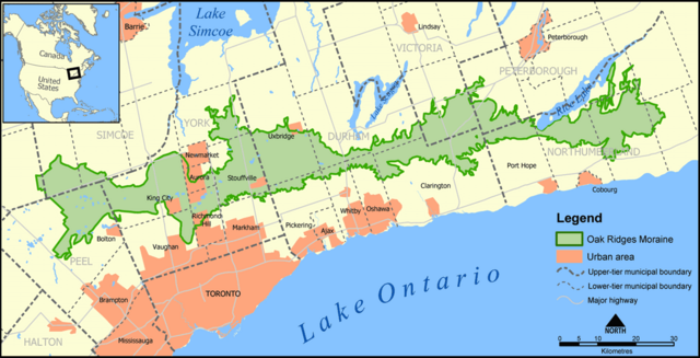
A map showing the Oak Ridges Moraine in southern Ontario, Canada.
Created by NormanEinstein, May 27, 2005.
| I, the copyright holder of this work, release this work into the public domain. This applies worldwide. In some countries this may not be legally possible; if so: I grant anyone the right to use this work for any purpose, without any conditions, unless such conditions are required by law. |
檔案歷史
撳個日期/時間去睇響嗰個時間出現過嘅檔案。
| 日期/時間 | 縮圖 | 尺寸 | 用戶 | 註解 | |
|---|---|---|---|---|---|
| 現時 | 2005年6月24號 (五) 14:17 | | 1,400 × 715(151 KB) | NormanEinstein | Updated map. Added labels for Bolton and King City. |
| 2005年6月7號 (二) 20:12 |  | 1,400 × 716(699 KB) | NormanEinstein | Doh. Forgot the highways on the last one. | |
| 2005年6月6號 (一) 21:18 |  | 1,400 × 715(601 KB) | NormanEinstein | Tidied up a bit. | |
| 2005年5月27號 (五) 20:41 |  | 1,000 × 510(377 KB) | NormanEinstein | A map showing the Oak Ridges Moraine in southern Ontario, Canada. Created by NormanEinstein, May 27, 2005. {{GFDL-self}} Category:Maps of Canada |
檔案用途
以下嘅1版用到呢個檔:
全域檔案使用情況
下面嘅維基都用緊呢個檔案:
- en.wikipedia.org嘅使用情況
- fr.wikipedia.org嘅使用情況