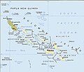
File:Political map of the Solomon Islands archipelago in 1989.jpg

預覽大細:690 × 600 像素。 第啲解像度:276 × 240 像素|552 × 480 像素|748 × 650 像素。
原本檔案 (748 × 650 像素,檔案大細:72 KB ,MIME類型:image/jpeg)
檔案歷史
撳個日期/時間去睇響嗰個時間出現過嘅檔案。
| 日期/時間 | 縮圖 | 尺寸 | 用戶 | 註解 | |
|---|---|---|---|---|---|
| 現時 | 2016年4月12號 (二) 02:06 |  | 748 × 650(72 KB) | Nimbosa | Reverted to version as of 02:02, 12 April 2016 (UTC) |
| 2016年4月12號 (二) 02:05 |  | 748 × 650(72 KB) | Nimbosa | restored to original color as on print, corrected color map | |
| 2016年4月12號 (二) 02:02 |  | 748 × 650(72 KB) | Nimbosa | restored to original color as on print, corrected color map | |
| 2007年3月1號 (四) 21:09 |  | 748 × 650(72 KB) | Pibwl |
檔案用途
以下嘅1版用到呢個檔:
全域檔案使用情況
下面嘅維基都用緊呢個檔案:
- als.wikipedia.org嘅使用情況
- ami.wikipedia.org嘅使用情況
- ast.wikipedia.org嘅使用情況
- bg.wikipedia.org嘅使用情況
- bn.wikipedia.org嘅使用情況
- ca.wikipedia.org嘅使用情況
- ceb.wikipedia.org嘅使用情況
- cs.wikipedia.org嘅使用情況
- da.wikipedia.org嘅使用情況
- el.wikipedia.org嘅使用情況
- en.wikipedia.org嘅使用情況
- en.wiktionary.org嘅使用情況
- es.wikipedia.org嘅使用情況
- fa.wikipedia.org嘅使用情況
- fi.wikipedia.org嘅使用情況
- fr.wikipedia.org嘅使用情況
- gl.wikipedia.org嘅使用情況
- hu.wikipedia.org嘅使用情況
- hy.wikipedia.org嘅使用情況
- hyw.wikipedia.org嘅使用情況
- id.wikipedia.org嘅使用情況
- it.wikipedia.org嘅使用情況
- ja.wikipedia.org嘅使用情況
- ja.wiktionary.org嘅使用情況
- ka.wikipedia.org嘅使用情況
睇呢個檔案嘅更多全域使用情況。


