File:Qaidam-basin-china.jpg
原本檔案 (1,280 × 1,280 像素,檔案大細:1.16 MB ,MIME類型:image/jpeg)
摘要
| 描述 |
Deutsch: STS040-613-011 Qaidambecken, China, Juni 1991
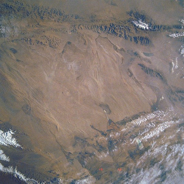
English: Image Caption: STS040-613-011 Qaidam Basin, China June 1991
This mostly east-looking view [here rotated to place north at the top] shows the Qaidam Basin. Located in the Northern Tibetan Plateau, the Qaidam Basin sets between two branches of the Kunlun Mountains. To the north (left edge) are the Altun Mountains and to the south (right edge) are the Qimantag Mountains. The arid basin is 350 miles (560 km) long and 100 miles (160 km) wide. A salt marsh occupies most of the basin. Oil fields and refineries are located in the west part (bottom center) of the basin. Iron ore is mined in the southern part of the basin. Coal deposits have been found in the Qaidam Basin. Cooler climate crops such as wheat, highland barley, millet, and potatoes are grown during the short, cool summer months. Español: STS040-613-011 Cuenca de Qaidam, China, Junio de 1991 |
||||
| 日期 | |||||
| 來源 |
https://eol.jsc.nasa.gov/SearchPhotos/photo.pl?mission=STS040&roll=613&frame=11 (original uploader information: http://eol.jsc.nasa.gov/sseop/efs/lores.pl?PHOTO=STS040-613-11) |
||||
| 作者 | NASA | ||||
| Photo center point |
|
協議
| This file is in the public domain in the United States because it was solely created by NASA. NASA copyright policy states that "NASA material is not protected by copyright unless noted". (See Template:PD-USGov, NASA copyright policy page or JPL Image Use Policy.) | ||
 |
Warnings:
|
Original upload log
Transferred from en.wikipedia to Commons by Quadell using CommonsHelper.
The original description page was here. All following user names refer to en.wikipedia.
- 2008-02-06 02:49 Mattisse 640×640× (385252 bytes) {{Information |Description=Quaidam Basin, China |Source=http://eol.jsc.nasa.gov/sseop/efs/lores.pl?PHOTO=STS040-613-11 |Date=2008-02-05 |Location=Quaidam Basin, China |Author=NASA |Permission= |other_versions= }}
| Annotations | This image is annotated: View the annotations at Commons |
檔案歷史
撳個日期/時間去睇響嗰個時間出現過嘅檔案。
| 日期/時間 | 縮圖 | 尺寸 | 用戶 | 註解 | |
|---|---|---|---|---|---|
| 現時 | 2019年8月7號 (三) 08:18 |  | 1,280 × 1,280(1.16 MB) | LlywelynII | Reverted to version as of 08:17, 7 August 2019 (UTC) STOP ROTATING THIS |
| 2019年8月7號 (三) 08:18 |  | 640 × 640(404 KB) | LlywelynII | Reverted to version as of 08:12, 7 August 2019 (UTC) testing | |
| 2019年8月7號 (三) 08:17 |  | 1,280 × 1,280(1.16 MB) | LlywelynII | let's try this again... | |
| 2019年8月7號 (三) 08:12 |  | 640 × 640(404 KB) | LlywelynII | North at top | |
| 2011年9月7號 (三) 19:34 |  | 640 × 640(376 KB) | File Upload Bot (Magnus Manske) | {{BotMoveToCommons|en.wikipedia|year={{subst:CURRENTYEAR}}|month={{subst:CURRENTMONTHNAME}}|day={{subst:CURRENTDAY}}}} {{Information |Description={{en|Qaidam Basin, China}} |Source=Transferred from [http://en.wikipedia.org en.wikipedia]; transferred to C |
檔案用途
以下嘅1版用到呢個檔:
全域檔案使用情況
下面嘅維基都用緊呢個檔案:
- az.wikipedia.org嘅使用情況
- de.wikipedia.org嘅使用情況
- en.wikipedia.org嘅使用情況
- es.wikipedia.org嘅使用情況
- hy.wikipedia.org嘅使用情況
- id.wikipedia.org嘅使用情況
- no.wikipedia.org嘅使用情況
- ru.wikipedia.org嘅使用情況
- sl.wikipedia.org嘅使用情況
- sr.wikipedia.org嘅使用情況
- sv.wikipedia.org嘅使用情況
- tr.wikipedia.org嘅使用情況
- vi.wikipedia.org嘅使用情況