File:Red Line departing Sheridan Rd.jpg
原本檔案 (3,007 × 1,875 像素,檔案大細:2.35 MB ,MIME類型:image/jpeg)
摘要
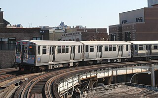
| 描述 | S curve, Chicago Elevated. 3940 North Sheridan Road. |
| 日期 | |
| 來源 | Red Line arriving at Sheridan Rd. |
| 作者 | Cragin Spring from Richmond Illinois, United States |
| Camera location | | View this and other nearby images on: OpenStreetMap |
|---|
協議
Ĉi tiu dosiero estas disponebla laŭ la permesilo Krea Komunaĵo Atribuite 2.0 Ĝenerala.
- 你可以:
- 去分享 – 複製、發佈同傳播呢個作品
- 再改 – 創作演繹作品
- 要遵照下面嘅條件:
- 署名 – 你一定要畀合適嘅表彰、畀返指向呢個授權條款嘅連結,同埋寫明有無改過嚟。你可以用任何合理方式去做,但唔可以用任何方式暗示授權人認可咗你或者你嘅使用方式。
| This image was originally posted to Flickr by Cragin Spring at https://flickr.com/photos/48922763@N04/21858769250. It was reviewed on 2016年3月21號 by FlickreviewR and was confirmed to be licensed under the terms of the cc-by-2.0. |
檔案歷史
撳個日期/時間去睇響嗰個時間出現過嘅檔案。
| 日期/時間 | 縮圖 | 尺寸 | 用戶 | 註解 | |
|---|---|---|---|---|---|
| 現時 | 2016年3月21號 (一) 14:45 |  | 3,007 × 1,875(2.35 MB) | Charterville | {{Information |Description=S curve, Chicago Elevated. 3940 North Sheridan Road. |Source=[https://www.flickr.com/photos/chiski/21858769250/ Red Line arriving at Sheridan Rd.] |Date=2015-10-07 13:20 |Author=[https://www.flickr.com/people/48922763@N04 Cra... |
檔案用途
以下嘅2版用到呢個檔:
全域檔案使用情況
下面嘅維基都用緊呢個檔案:
- bn.wikipedia.org嘅使用情況
- en.wikipedia.org嘅使用情況
- es.wikipedia.org嘅使用情況
- simple.wikipedia.org嘅使用情況
- th.wikipedia.org嘅使用情況