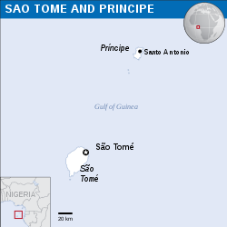
File:São Tomé and Príncipe - Location Map (2013) - STP - UNOCHA.svg

呢個「SVG」檔案嘅呢個「PNG」預覽嘅大細:250 × 250 像素。 第啲解像度:240 × 240 像素|480 × 480 像素|768 × 768 像素|1,024 × 1,024 像素|2,048 × 2,048 像素。
原本檔案 (SVG檔案,表面大細: 250 × 250 像素,檔案大細:348 KB)
檔案歷史
撳個日期/時間去睇響嗰個時間出現過嘅檔案。
| 日期/時間 | 縮圖 | 尺寸 | 用戶 | 註解 | |
|---|---|---|---|---|---|
| 現時 | 2016年9月10號 (六) 06:09 |  | 250 × 250(348 KB) | Wereldburger758 | Resized page to drawing. Removal watermark. Validation of image. |
| 2014年5月8號 (四) 01:14 |  | 254 × 254(372 KB) | UN OCHA maps bot | == {{int:filedesc}} == {{Information |description={{en|1=Locator map of São Tomé and Príncipe.}} |date=2013 |source={{en|1=[http://reliefweb.int/map/sao-tome-and-principe/sao-tome-and-principe-location-map-2013 Sao... |
檔案用途
以下嘅1版用到呢個檔:
全域檔案使用情況
下面嘅維基都用緊呢個檔案:
- ar.wikipedia.org嘅使用情況
- arz.wikipedia.org嘅使用情況
- ast.wikipedia.org嘅使用情況
- ca.wikipedia.org嘅使用情況
- ceb.wikipedia.org嘅使用情況
- ee.wikipedia.org嘅使用情況
- el.wikipedia.org嘅使用情況
- en.wikipedia.org嘅使用情況
- eo.wikipedia.org嘅使用情況
- es.wikipedia.org嘅使用情況
- eu.wikipedia.org嘅使用情況
- ga.wikipedia.org嘅使用情況
- gl.wikipedia.org嘅使用情況
- ha.wikipedia.org嘅使用情況
- ht.wikipedia.org嘅使用情況
- hu.wikipedia.org嘅使用情況
- ia.wikipedia.org嘅使用情況
- id.wikipedia.org嘅使用情況
- kab.wikipedia.org嘅使用情況
- la.wikipedia.org嘅使用情況
- mdf.wikipedia.org嘅使用情況
- mzn.wikipedia.org嘅使用情況
- pl.wikipedia.org嘅使用情況
- pt.wikipedia.org嘅使用情況
- sd.wikipedia.org嘅使用情況
- szl.wikipedia.org嘅使用情況
- te.wikipedia.org嘅使用情況
- tt.wikipedia.org嘅使用情況
- uk.wikipedia.org嘅使用情況
- vi.wikipedia.org嘅使用情況
- www.wikidata.org嘅使用情況
