File:Serbia (orthographic projection).svg

呢個「SVG」檔案嘅呢個「PNG」預覽嘅大細:600 × 600 像素。 第啲解像度:240 × 240 像素|480 × 480 像素|768 × 768 像素|1,024 × 1,024 像素|2,048 × 2,048 像素。
原本檔案 (SVG檔案,表面大細: 2,048 × 2,048 像素,檔案大細:1.45 MB)
摘要
| 描述 |
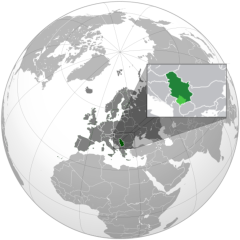
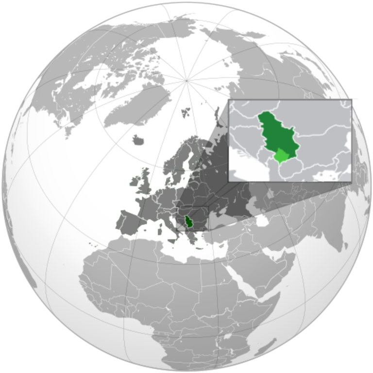
English: Serbia orthographic projection |
||
| 日期 | |||
| 來源 |
自己作品 This vector image includes elements that have been taken or adapted from this file: This vector image includes elements that have been taken or adapted from this file: This vector image includes elements that have been taken or adapted from this file: |
||
| 作者 | Милан Јелисавчић | ||
| Other versions |
.svg)
|
||
| SVG genesis |
.svg)
.svg)
.svg)
.svg)
.svg)
.svg)
.svg)
.svg)
.svg)
.svg)
.svg)
.svg)
.svg)
.svg)
.svg)
.svg)
.svg)
.svg)
.svg)
.svg)
.svg)
.svg)
.svg)
.svg)
.svg)
.svg)
.svg)
.svg)
.svg)
.svg)
.svg)
.svg)
.svg)
.svg)
.svg)
.svg)
.svg)
.svg)
.svg)
.svg)
.svg)
.svg)
.svg)
.svg)
.svg)
.svg)
.svg)
.svg)
.svg)
.svg)
.svg)
.svg)
.svg)
.svg)
.svg)
.svg)
.svg)
.svg)
.svg)
.svg)
.svg)
.svg)
.svg)
.svg)
.svg)
.svg)
.svg)
.svg)
.svg)
.svg)
.svg)
.svg)
.svg)

.svg)

.svg)

.svg)
.svg)
.svg)
.svg)
.svg)
.svg)
.svg)


.svg)
.svg)
.svg)
.svg)
.svg)
.svg)
.svg)

.svg)
.svg)
.svg)
.svg)
.svg)
.svg)
.svg)
.svg)
.svg)

.svg)
.svg)
.svg)
.svg)
.svg)
.svg)
.svg)
_without_national_boundaries.svg)
.svg)
.svg)
.svg)
.svg)
.svg)
.svg)

.svg)
.svg)
.png)
.svg)
.svg)
.svg)
.svg)

.svg)
.svg)
.svg)
.svg)
.svg)
.svg)
.svg)
.svg)
.svg)
.svg)
.svg)

.svg)
.svg)
.svg)
.svg)
.svg)
.svg)
.svg)
.svg)
.svg)

.svg)
.svg)

.svg)
.svg)
.svg)
.svg)
.svg)
.svg)
.svg)
.svg)
.svg)
.svg)
.svg)
.svg)
.svg)
.svg)
.svg)
.svg)
.svg)
.svg)
.svg)
.svg)
.svg)
.svg)
.svg)
.svg)
.svg)
.svg)
.svg)
_-_Crimea_disputed.svg)
.svg)
.svg)
.svg)
.svg)
.svg)
.svg)
.svg)
.svg)
.svg)
.svg)
.svg)
_political.svg)
.svg)
.svg)
.svg)
.svg)
_-_Crimea_disputed_-_no_borders.svg)
.svg)
.svg)
.svg)
.svg)
.svg)
.svg)
.svg)
.svg)
.svg)
.svg)
.svg)

.svg)
.svg)
.svg)

.png)
.svg)
.svg)
.svg)
.svg)
.svg)
.svg)
.svg)
.svg)
.svg)
.svg)
.svg)
.svg)
.svg)
.svg)
.svg)
.svg)
.svg)
.svg)
.svg)
.svg)
.svg)
.svg)
.svg)
.svg)
.svg)
.svg)
.svg)
.svg)
.svg)
.svg)
.svg)
.svg)
.svg)
.svg)
.png)
.svg)
.svg)
.svg)
_(orthographic_projection).png)

.svg?uselang=yue)
.svg)
.svg)
協議
我,呢份作品嘅作者,決定用以下許可發佈呢件作品:
呢個檔案用共享創意 姓名標示-非商業性-相同方式分享3.0 未本地化版本條款授權。
- 你可以:
- 去分享 – 複製、發佈同傳播呢個作品
- 再改 – 創作演繹作品
- 要遵照下面嘅條件:
- 署名 – 你一定要畀合適嘅表彰、畀返指向呢個授權條款嘅連結,同埋寫明有無改過嚟。你可以用任何合理方式去做,但唔可以用任何方式暗示授權人認可咗你或者你嘅使用方式。
- 相同方式分享 – 如果你用任何方式改過呢個作品,你必須要用返原本或者相似嘅條款發佈。
檔案歷史
撳個日期/時間去睇響嗰個時間出現過嘅檔案。
.svg&dir=prev)
.svg&offset=20120121141735)
.svg&offset=&limit=20)
.svg&offset=&limit=50)
.svg&offset=&limit=100)
.svg&offset=&limit=250)
.svg&offset=&limit=500)
| 日期/時間 | 縮圖 | 尺寸 | 用戶 | 註解 | |
|---|---|---|---|---|---|
| 現時 | 2022年12月27號 (二) 18:34 | | 2,048 × 2,048(1.45 MB) | Iktsokh | More correct visualization of the dividing line on the territory of the Caucasus Range |
| 2022年2月24號 (四) 06:47 |  | 541 × 541(205 KB) | Ahmet Q. | Reverted to version as of 18:50, 15 December 2021 (UTC) Rv POV-pushing | |
| 2021年12月26號 (日) 18:32 |  | 541 × 541(338 KB) | Vacant0 | Reverted to version as of 18:33, 4 June 2021 (UTC) | |
| 2021年12月15號 (三) 18:50 |  | 541 × 541(205 KB) | موسى | Reverted to version as of 23:32, 30 June 2020 (UTC) - саботаж; зеленый цвет в Африке | |
| 2021年6月4號 (五) 18:33 |  | 541 × 541(338 KB) | Vacant0 | Reverted to version as of 15:49, 29 December 2019 (UTC) | |
| 2020年6月30號 (二) 23:32 |  | 541 × 541(205 KB) | Yeetstuff | Fixed inaccuracies (EU as whole country, French Guiana colored in, Eritrea and South Sudan not shown, Yemen split) | |
| 2019年12月29號 (日) 15:49 |  | 541 × 541(338 KB) | Goran tek-en | Added border for South Sudan as requested by Maphobbyist | |
| 2012年1月22號 (日) 00:37 |  | 541 × 541(654 KB) | Zenfiric | minor corrections | |
| 2012年1月21號 (六) 14:44 |  | 541 × 541(651 KB) | Zenfiric | minor correction | |
| 2012年1月21號 (六) 14:17 |  | 541 × 541(651 KB) | Zenfiric | Projection with inset |
檔案用途
以下嘅1版用到呢個檔:
全域檔案使用情況
下面嘅維基都用緊呢個檔案:
- af.wikipedia.org嘅使用情況
- arc.wikipedia.org嘅使用情況
- ar.wikipedia.org嘅使用情況
- العلاقات العراقية الصربية
- العلاقات الأمريكية الصربية
- العلاقات الأنغولية الصربية
- العلاقات الصربية الكورية الجنوبية
- العلاقات الإريترية الصربية
- العلاقات السويسرية الصربية
- العلاقات الألمانية الصربية
- العلاقات الصربية الليختنشتانية
- العلاقات البوليفية الصربية
- العلاقات الصربية الموزمبيقية
- العلاقات الألبانية الصربية
- العلاقات البلجيكية الصربية
- العلاقات الإثيوبية الصربية
- العلاقات البيلاروسية الصربية
- العلاقات الصربية الطاجيكستانية
- العلاقات الروسية الصربية
- العلاقات الرومانية الصربية
- العلاقات الأرجنتينية الصربية
- العلاقات الصربية الغامبية
- العلاقات الصربية القبرصية
- العلاقات السيراليونية الصربية
- العلاقات الصربية النيبالية
- العلاقات الصربية الليبيرية
- العلاقات التشيكية الصربية
- العلاقات الصربية الميانمارية
- العلاقات الصربية الكندية
- العلاقات السعودية الصربية
- العلاقات الزيمبابوية الصربية
- العلاقات الإسرائيلية الصربية
- العلاقات البالاوية الصربية
- العلاقات الصربية المالية
- العلاقات الصربية النيجيرية
- العلاقات اليمنية الصربية
- العلاقات الصربية الفانواتية
- العلاقات الغابونية الصربية
- العلاقات البنمية الصربية
- العلاقات الصربية الكوبية
- العلاقات الجورجية الصربية
- العلاقات التونسية الصربية
- العلاقات الصربية الكورية الشمالية
- العلاقات الهندية الصربية
- العلاقات اليابانية الصربية
- العلاقات الإيطالية الصربية
- العلاقات الصربية الناوروية
- العلاقات الأسترالية الصربية
- العلاقات الزامبية الصربية
- العلاقات الصربية الفيجية
- العلاقات المارشالية الصربية
睇呢個檔案嘅更多全域使用情況。
.svg)
.svg)