File:Sint Maarten-CIA WFB Map.png
冇更高解像度嘅圖像。
Sint_Maarten-CIA_WFB_Map.png (330 × 353 像素,檔案大細:14 KB ,MIME類型:image/png)

|
This locator map image could be recreated using vector graphics as an SVG file. This has several advantages; see Commons:Media for cleanup for more information. If an SVG form of this image is already available, please upload it. After uploading an SVG, replace this template with {{vector version available|new image name.svg}}.
|
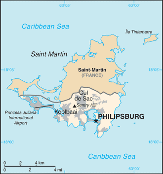
| 描述 | Map of Sint Maarten from the 2010-10-22 revision of the World Factbook |
| 日期 | |
| 來源 | World Factbook website |
| 作者 | Directorate of Intelligence, CIA |
This image is in the public domain because it contains materials that originally came from the United States Central Intelligence Agency's World Factbook.
|
 |
檔案歷史
撳個日期/時間去睇響嗰個時間出現過嘅檔案。
| 日期/時間 | 縮圖 | 尺寸 | 用戶 | 註解 | |
|---|---|---|---|---|---|
| 現時 | 2010年10月23號 (六) 11:32 | | 330 × 353(14 KB) | Hoshie | {{Information |Description= Map of {{w|Sint Maarten}} from the 2010-10-22 revision of the World Factbook |Source= [https://www.cia.gov/library/publications/the-world-factbook/maps/maptemplate_sk.html World Factbook website] |Date= 2010-10-22 |Author= Dire |
檔案用途
以下嘅1版用到呢個檔:
全域檔案使用情況
下面嘅維基都用緊呢個檔案:
- af.wikipedia.org嘅使用情況
- bn.wikipedia.org嘅使用情況
- ceb.wikipedia.org嘅使用情況
- el.wikipedia.org嘅使用情況
- en.wikipedia.org嘅使用情況
- fa.wikipedia.org嘅使用情況
- fr.wikipedia.org嘅使用情況
- gcr.wikipedia.org嘅使用情況
- gom.wikipedia.org嘅使用情況
- hi.wikipedia.org嘅使用情況
- hu.wikipedia.org嘅使用情況
- ia.wikipedia.org嘅使用情況
- id.wikipedia.org嘅使用情況
- incubator.wikimedia.org嘅使用情況
- it.wikipedia.org嘅使用情況
- ja.wikipedia.org嘅使用情況
- lad.wikipedia.org嘅使用情況
- lb.wikipedia.org嘅使用情況
- mk.wikipedia.org嘅使用情況
- ml.wikipedia.org嘅使用情況
- nl.wikipedia.org嘅使用情況
- pa.wikipedia.org嘅使用情況
- pl.wikipedia.org嘅使用情況
- ru.wikipedia.org嘅使用情況
- sc.wikipedia.org嘅使用情況
- shn.wikipedia.org嘅使用情況
- simple.wikipedia.org嘅使用情況
- su.wikipedia.org嘅使用情況
- ta.wikipedia.org嘅使用情況
- to.wikipedia.org嘅使用情況
- tr.wikipedia.org嘅使用情況
- tt.wikipedia.org嘅使用情況
- uk.wikipedia.org嘅使用情況
- ur.wikipedia.org嘅使用情況
- vec.wikipedia.org嘅使用情況
- www.wikidata.org嘅使用情況
- zh.wikipedia.org嘅使用情況