File:Snow-cholera-map.jpg

原本檔案 (889 × 869 像素,檔案大細:248 KB ,MIME類型:image/jpeg)
摘要
| Description |
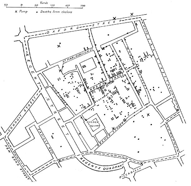
English: A variant of the original map drawn by Dr. John Snow (1813-1858), a British physician who is one of the founders of medical epidemiology, showing cases of cholera in the London epidemics of 1854, clustered around the locations of water pumps.
Español: Mapa original dibujado por el Dr. John Snow (1813-1858), médico inglés precursor de la epidemiología, que muestra los casos de cólera en la epidemia ocurrida en Londres en 1854. Los puntos muestran la localización de las personas afectadas por beber agua de los pozos (cruces)
Português: Mapa original elaborado pelo Dr. John Snow (1813-1858), médico britânico, um dos precursores da epidemiologia. O mapa mostra casos de cólera numa epidemia ocorrida em Londres em 1854. Os pontos indicam a localização de pessoas afetadas pela cólera por consumir água de poços, indicados pelas cruzes.
Nederlands: De originele kaart gemaakt door Dr. John Snow (1813-1858), een Engelse arts en een van de grondleggers van de medische epidemiologie, laat zien waar gevallen van cholera plaatsvonden tijdens de Londense epidemie van 1854, in relatie tot de waterpompen (kruisjes).
Deutsch: Variante einer im Original von Dr. John Snow (1813–1858) gezeichneten Karte. Der britische Arzt war ein Pionier der epidemiologischen Erforschung der Cholera. Die Karte zeigt Cholerafälle bei der Epidemie in London 1854, die sich bei einer Wasserpumpe (an der Broad Street) häufen. |
|||||||||
| 來源 |
Unknown source Transferred from en.wikipedia to Commons. |
|||||||||
| Creator |
after John Snow |
|||||||||
| Geotemporal data | ||||||||||
| Bounding box |
|
|||||||||
| Georeferencing | ||||||||||
| Other versions | File:Snow-cholera-map-1.jpg, the original | |||||||||
協議
|
呢個作品喺來源國同埋其他版權期限係作者過身後70年或以下嘅國家同地區屬於公有領域。
| |
| This file has been identified as being free of known restrictions under copyright law, including all related and neighboring rights. | |
檔案歷史
撳個日期/時間去睇響嗰個時間出現過嘅檔案。
| 日期/時間 | 縮圖 | 尺寸 | 用戶 | 註解 | |
|---|---|---|---|---|---|
| 現時 | 2005年11月6號 (日) 11:10 | | 889 × 869(248 KB) | Corso | *{{english}}The original map drawn by Dr. John Snow (1813-1858), a British physician who is one of the founders of medical epidemiology, showing cases of cholera in the London epidemics of 1854, clustered around the locations of water pumps. *{{spanish}} |
檔案用途
以下嘅1版用到呢個檔:
全域檔案使用情況
下面嘅維基都用緊呢個檔案:
- ast.wikipedia.org嘅使用情況
- bg.wikipedia.org嘅使用情況
- bn.wikipedia.org嘅使用情況
- bs.wikipedia.org嘅使用情況
- ca.wikipedia.org嘅使用情況
- cs.wikipedia.org嘅使用情況
- de.wikipedia.org嘅使用情況
- en.wikipedia.org嘅使用情況
- en.wikiversity.org嘅使用情況
- eo.wikipedia.org嘅使用情況
- es.wikipedia.org嘅使用情況
- et.wikipedia.org嘅使用情況
- eu.wikipedia.org嘅使用情況
- ext.wikipedia.org嘅使用情況
- fi.wikipedia.org嘅使用情況
- fr.wikipedia.org嘅使用情況
- hi.wikipedia.org嘅使用情況
- hr.wikipedia.org嘅使用情況
- hu.wikipedia.org嘅使用情況
- io.wikipedia.org嘅使用情況
- it.wikipedia.org嘅使用情況
- ja.wikipedia.org嘅使用情況
睇呢個檔案嘅更多全域使用情況。