File:Usgs map albers equal area conic.PNG
冇更高解像度嘅圖像。
Usgs_map_albers_equal_area_conic.PNG (402 × 170 像素,檔案大細:38 KB ,MIME類型:image/png)

|
This map image could be recreated using vector graphics as an SVG file. This has several advantages; see Commons:Media for cleanup for more information. If an SVG form of this image is already available, please upload it. After uploading an SVG, replace this template with {{vector version available|new image name.svg}}.
|
摘要
| 描述 |
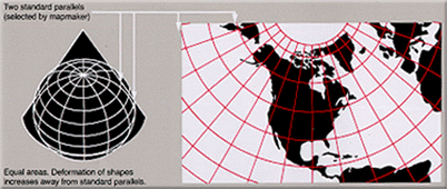
English: Condensed explanation of Albers conic-projection maps, converted to PNG format from larger USGS file of GIF format. See enlarged view below, using a wikitable to expand beyond original size. |
| 日期 | |
| 來源 |
derivative from USGS image file, |
| 作者 | derived from US Government USGS |
| Other versions |
Narrowed image with larger lettering, taller layout, 29% compressed (GIF format): |
協議
| I, the copyright holder of this work, release this work into the public domain. This applies worldwide. In some countries this may not be legally possible; if so: I grant anyone the right to use this work for any purpose, without any conditions, unless such conditions are required by law. |
This image is in the public domain in the United States because it only contains materials that originally came from the United States Geological Survey, an agency of the United States Department of the Interior. For more information, see the official USGS copyright policy.
|
檔案歷史
撳個日期/時間去睇響嗰個時間出現過嘅檔案。
| 日期/時間 | 縮圖 | 尺寸 | 用戶 | 註解 | |
|---|---|---|---|---|---|
| 現時 | 2005年2月17號 (四) 14:22 | | 402 × 170(38 KB) | Quadell | World map projection ([http://erg.usgs.gov/isb/pubs/MapProjections/projections.html source)]{{PD-USGov-USGS}}Category:World mapsCategory:Map projectionsCategory:Map diagrams |
檔案用途
以下嘅1版用到呢個檔:
全域檔案使用情況
下面嘅維基都用緊呢個檔案:
- en.wikipedia.org嘅使用情況
- es.wikipedia.org嘅使用情況
- fi.wikipedia.org嘅使用情況
- it.wikipedia.org嘅使用情況
- ja.wikipedia.org嘅使用情況
- nl.wikipedia.org嘅使用情況
- pt.wikipedia.org嘅使用情況
- ru.wikipedia.org嘅使用情況
- zh.wikipedia.org嘅使用情況