File:Willandra Lakes.png

預覽大細:482 × 600 像素。 第啲解像度:193 × 240 像素|560 × 697 像素。
原本檔案 (560 × 697 像素,檔案大細:887 KB ,MIME類型:image/png)
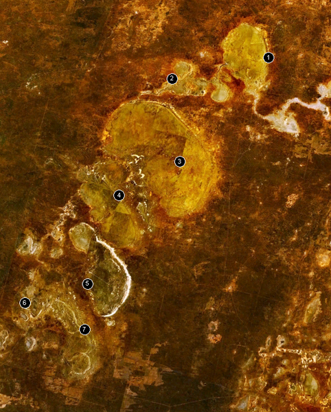
The w:Willandra Lakes Region in Australia.
- Lake Mulurulu
- Willandra Creek
- Garnpung Lake
- Lake Leaghur
- Lake Mungo
- Lake Arumpo
- Chibnalwood Lakes
| This image is in the public domain because it is a screenshot from NASA’s globe software World Wind using a public domain layer, such as Blue Marble, MODIS, Landsat, SRTM, USGS or GLOBE.
|
 |
檔案歷史
撳個日期/時間去睇響嗰個時間出現過嘅檔案。
| 日期/時間 | 縮圖 | 尺寸 | 用戶 | 註解 | |
|---|---|---|---|---|---|
| 現時 | 2005年12月28號 (三) 13:08 | | 560 × 697(887 KB) | Stephen Bain | The w:Willandra Lakes Region in Australia. # Lake Mulurulu # Willandra Creek # Garnpung Lake # Lake Leaghur # Lake Mungo # Lake Arumpo # Chibnalwood Lakes {{PD-WorldWind}} |
檔案用途
以下嘅1版用到呢個檔:
全域檔案使用情況
下面嘅維基都用緊呢個檔案:
- ast.wikipedia.org嘅使用情況
- be.wikipedia.org嘅使用情況
- ca.wikipedia.org嘅使用情況
- cs.wikipedia.org嘅使用情況
- de.wikipedia.org嘅使用情況
- de.wikivoyage.org嘅使用情況
- en.wikipedia.org嘅使用情況
- en.wikibooks.org嘅使用情況
- en.wikivoyage.org嘅使用情況
- es.wikipedia.org嘅使用情況
- fa.wikipedia.org嘅使用情況
- fi.wikipedia.org嘅使用情況
- fr.wikipedia.org嘅使用情況
- he.wikipedia.org嘅使用情況
- he.wikivoyage.org嘅使用情況
- hr.wikipedia.org嘅使用情況
- hu.wikipedia.org嘅使用情況
- it.wikipedia.org嘅使用情況
- it.wikivoyage.org嘅使用情況
- ja.wikipedia.org嘅使用情況
- ja.wikivoyage.org嘅使用情況
- lt.wikipedia.org嘅使用情況
- mt.wikipedia.org嘅使用情況
- my.wikipedia.org嘅使用情況
- ne.wikipedia.org嘅使用情況
- nl.wikipedia.org嘅使用情況
- no.wikipedia.org嘅使用情況
- pl.wikipedia.org嘅使用情況
- pt.wikipedia.org嘅使用情況
- ro.wikipedia.org嘅使用情況
- ru.wikipedia.org嘅使用情況
- sh.wikipedia.org嘅使用情況
- simple.wikipedia.org嘅使用情況
- sk.wikipedia.org嘅使用情況
- sv.wikipedia.org嘅使用情況
睇呢個檔案嘅更多全域使用情況。