File:AMH-5648-KB Map of Guandong, China.jpg
原本檔案 (2,400 × 1,990 像素,檔案大細:650 KB ,MIME類型:image/jpeg)
摘要
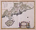
Nederlands: Kaart van Guandong, China
English: Map of Guandong, China( |
||||||||||||||||||||||||||||||||||||||||||||||||||
|---|---|---|---|---|---|---|---|---|---|---|---|---|---|---|---|---|---|---|---|---|---|---|---|---|---|---|---|---|---|---|---|---|---|---|---|---|---|---|---|---|---|---|---|---|---|---|---|---|---|---|
| 作者 |
creator QS:P170,Q379677
creator QS:P170,Q1243676
Nederlands: Joan Blaeu sr. (uitgever), Martino Martini (gewerkt naar)
English: Joan Blaeu sr. (publisher), Martino Martini (copied after) |
|||||||||||||||||||||||||||||||||||||||||||||||||
| 題 |
Nederlands: Kaart van Guandong, China
English: Map of Guandong, China |
|||||||||||||||||||||||||||||||||||||||||||||||||
| 描述 |
Nederlands: Kaart van Guandong (China) uit de Atlas van der Hagen, Koninklijke Bibliotheek, Den Haag Deel 4.
Deze kaart van de Chinese provincie Guandong waarop ook het tegenwoordige Hong-Kong is afgebeeld, behoort tot een atlas van China samengesteld door de Italiaanse missionaris Martino Martini (1614-1661). Martini maakte in 1653 op zijn terugreis naar Rome een tussenstop in Amsterdam, waar hij zijn atlas verkocht aan de uitgever Joan Blaeu (1598-1673). Vanaf 1655 bracht Blaeu deze atlas als `Atlas Sinensis' in verschillende talen op de markt. De atlas werd ook integraal opgenomen in zijn Atlas Maior uit 1662.
English: Map of Guandong (China) taken from the Atlas van der Hagen, Koninklijke Bibliotheek, The Hague, part 4.
This map of the Chinese province of Guandong, which also depicts today's Hong Kong, belongs to an atlas of China compiled by the Italian missionary Martino Martini (1614-1661). On his return journey to Rome in 1653 Martini stopped off in Amsterdam, where he sold his atlas to the publisher Joan Blaeu (1598-1673). From 1655 onwards Blaeu published this atlas in various languages under the title 'Atlas Sinensis'. The atlas was also incorporated in its entirety into Blaeu's Atlas Maior in 1662. |
|||||||||||||||||||||||||||||||||||||||||||||||||
| 日期 |
1655年 date QS:P571,+1655-00-00T00:00:00Z/9 |
|||||||||||||||||||||||||||||||||||||||||||||||||
| Medium |
Nederlands: koperdruk op papier
English: copperplate printing on paper |
|||||||||||||||||||||||||||||||||||||||||||||||||
| Dimensions |
高度:50cm;闊度:41cm dimensions QS:P2048,50U174728 dimensions QS:P2049,41U174728 |
|||||||||||||||||||||||||||||||||||||||||||||||||
| Collection |
institution QS:P195,Q1526131 |
|||||||||||||||||||||||||||||||||||||||||||||||||
| Accession number |
1049B13_049 |
|||||||||||||||||||||||||||||||||||||||||||||||||
| Inscriptions |
QVANTVNG, IMPERII SINARVM PROVINCIA DVODECIMA
author: Excudit Joannes Blaeu |
|||||||||||||||||||||||||||||||||||||||||||||||||
| 註 |
English: Subjects: Asians & Africans, banderole / cartouche / ornamentation, chart / map / plan
Nederlands: Onderwerpen: Aziaten & Afrikanen, banderol / cartouche / versiering, plattegrond / kaart
English: Post: this image is related to a VOC trading post called Kanton/Guangzhou |
|||||||||||||||||||||||||||||||||||||||||||||||||
| Source/Photographer |
|
|||||||||||||||||||||||||||||||||||||||||||||||||
| 許可 (重用呢個檔案) |
|
|||||||||||||||||||||||||||||||||||||||||||||||||
| Object location | 23° 08′ 45.75″ N, 113° 15′ 38.48″ E | View this and other nearby images on: OpenStreetMap |
|---|
Captions
Add a one-line explanation of what this file represents
Items portrayed in this file
圖中顯示嘅係
23°8'45.751"N, 113°15'38.480"E
image/jpeg
665,563 字節
1,990 像素
2,400 像素
檔案歷史
撳個日期/時間去睇響嗰個時間出現過嘅檔案。
| 日期/時間 | 縮圖 | 尺寸 | 用戶 | 註解 | |
|---|---|---|---|---|---|
| 現時 | 2014年6月10號 (二) 11:01 |  | 2,400 × 1,990(650 KB) | HuskyBot | == {{int:filedesc}} == {{Artwork |title = {{nl|1=Kaart van Guandong, China}} {{en|1=Map of Guandong, China}} |description = {{nl|1=Kaart van Guandong (China) uit de Atlas van der Hagen, Koninklijke Bibliotheek,... |
檔案用途
以下嘅1版用到呢個檔:


